Garmin
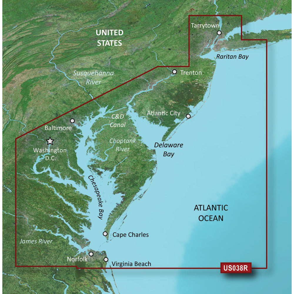
Garmin BlueChart g3 Vision HD - VUS038R - New York - Chesapeake - microSD/SD [010-C1004-00]
BlueChart® g3 Vision® HD - VUS038R - New York - Chesapeake - microSD™/SD™ Coverage: Raritan Bay to Virginia Beach including Tarrytown, Fire Island Inlet, the entire New Jersey coastline, the C&D Canal, Delaware Bay, the Delaware River to Trenton, Chesapeake Bay, Baltimore, the Potomac River to Washington D.C., Chincoteague Bay, Cape Charles, Newport News, and Norfolk. Premier Coastal Navigation Charts Provides industry-leading coverage, clarity and detail with updated coastal charts that feature integrated Garmin and Navionics® data Auto Guidance¹ technology uses your desired depth and overhead clearance to calculate routes and show a suggested path to follow High-resolution relief shading combines color and shadow to give you an easy-to-interpret, clearer view of bottom structure than contour lines alone Depth Range Shading provides up to 10 depth ranges, enabling you to view your target depth at a glance Up to 1’ contours provide a more accurate depiction of the bottom structure for improved fishing charts and navigation in swamps, canals and marinas Experience unparalleled coverage and brilliant detail on the water. BlueChart g3 Vision coastal charts provide industry-leading coverage, clarity and detail with integrated Garmin and Navionics data, Auto Guidance technology and high-resolution relief shading.. Auto Guidance Technology The Auto Guidance feature¹ uses your desired depth and overhead clearance to calculate a route and a suggested path to follow. High-resolution Relief Shading Feature High-resolution relief shading combines color and shadow to give you an easy-to-interpret, clearer view of bottom structure than contour lines alone. Up to 1’ Contours The closer the contour lines, the more accurate the depiction of the bottom structure for improved fishing...
- Ships from Mutiny Marine and Outdoors LLC
- Confirm fitment, size, and compatibility before purchase
Choose options